Hiking in Panamá

Rich in tropical flora, diverse wildlife, and picture-worthy sights, Panamá trails offer something for every hiker, from easy and scenic excursions with city views to challenging and secluded trails around extinct volcanoes, islands, and lush rainforests.

Senderismo Hiking Gamboa

Easy to Challenging Urban Trails

Panama City may be a modern metropolis set along the Pacific Ocean, but hiking is a popular pastime. It’s the only city worldwide with three national parks within city limits, home to exotic wildlife, majestic views, and easy to challenging hiking trails.

A short car ride from Panama City is Metropolitan Natural Park. As you hike one of the seven marked trails that range from easy to moderate, perfect for families, you’ll feel far from civilization in the 573-acre (or 232 hectares). El Roble Trail is a 0.7 km (0.4 mi) flat pathway that connects to the visitor's center. The Caobos trail is a more challenging hike 0.9 km (0.4 mi); the Cieneguita is longer, 1.1 km (0.7 mi), and the Mono Titi Road wider 1.1 km (0.7 mi). The park is home to one of the most spectacular Panamá city skyline views at the Cerro Cedro Lookout Point.

North of Metropolitan Natural Park, you’ll find more views, wildlife, and even history, at the 3642 hectare (9,000-acre) Camino de Cruces National Park. The Camino de Cruces Trail originated in 1527 and was used by the Spanish to link Old Panama City to the Venta de Cruces and transport goods like textiles, spices, silver, and gold back to the homeland. The 8-14 km (5.9-miles) trail (point-to-point), classified as moderately challenging, takes over three hours to complete. This park offers no facilities, and we highly recommend hiking with a partner and bringing water.

Right above Cruces is Soberania National Park, the most expansive rainforest in this area at 22.257 hectare (55,000 acres), near the banks of the famous Panama Canal and with the Chagres River running through it. Some of the top hiking trails include Pipeline Road, a 6-8 km (4.5-mile) round trip hike that takes nearly two hours to complete, and Plantation Road, an over three-hour hike and a 11-13 km (7.8-mile) hike round trip.

isla Taboga

Trail Adventures in the Islands

Hop on a ferry from Panama City to Taboga Island to find adventure on and off the beach. Within 30 minutes, you're on a volcanic island rich with tropical wildlife, beaches, and three hiking trails.

The Cerro la Cruz Trail takes you to the highest point of Taboga with 305 mts (1000 feets) of elevation, featuring a spectacular view of the bay, Panama City, and the boats waiting to cross the Panama Canal. The other trails are Cerro Vigia, a 3-8km (2.5-mile) loop, and the Bahia Honda, a circular circuit.

On the west end of Panama is Bocas del Toro province, which includes a chain of islands, including Isla Colon, where there are several trails, from Bluff Beach to Boca del Drago to Starfish Beach. Another trail leads to the La Gruta Caves, where you may see live bats. The best way to experience the trail is on a guided tour.   

You can hike the perimeter of the smallest of the major islands in Bocas del Toro, Carenero, in an hour or two unless you decide to stop along the way to enjoy the beaches and restaurants in town.   

Another Bocas del Toro island, Bastimentos, also offers diverse trails. Go on a guided tour in Salt Creek, a Ngäbe community, where you can hike through a rainforest on the Path of the Cayman, near the coast on Path of the Pelican, in parts of the Bastimentos National Marine Park, on the Path of Long Beach, and the Path of the Medicine, where you can learn about medicinal plants. In the Ngäbe community of Bahia Honda is the Sloth Trail that winds through the forest to a bat cave, also on a guided tour. Enjoy the mangroves and beach on the Red Frog Beach Trail.

volcan baru

In and Around the Baru Volcano

Whether you dream of hiking up a volcano or through a rainforest, Panamá has the trail for you. For a hike with towering heights, take a trek through Baru Volcano National Park, surrounded by the Panamanian towns of Boquete, Volcan, and Cerro Punta.

The park is situated in western Panama within the Chiriqui Province and is the highest point in Panamá at 3,474 meters (11.398 ft) high – the 12th highest peak found in Central America. 

The extinct volcano separates Volcan and Cerro Punta, both in the Tierras Altas district, from Boquete. Trails vary in difficulty from easy to challenging. Both sides have access to hiking trails. Tierras Altas is shorter but challenging, Boquete trail is longer and of moderate difficulty while the Volcan side it's extremely hard but with amazing views . It’s the only place in the world where, on the clearest of days, you can see the Atlantic and Pacific oceans at the same time. 

Other memorable hikes in the area include the Los Quetzales Trail, which weaves through the national park and connects Cerro Punta and Boquete. It typically takes four hours to hike one way. Another must-see hiking spot is La Amistad International Park in Tierras Altas, named a World Heritage Site by UNESCO in 1983. You don’t want to miss the park’s Panama Verde Trail, an easy 0.6 km circuit that takes anywhere from 30 minutes to an hour to complete. 

Another stunning trail outside of Boquete is The Lost Waterfalls Trail. During your visit, you'll find hanging vines, lush trees with gigantic leaves accompanied by melodies of birds, and a natural water show.

In Boquete, you’ll find the El Pianista Trail, which features a narrow canyon path. Just four kilometers outside of town, it takes approximately three hours at an elevation of 609m (2,000 feet) to hike, and much of it is among the clouds. 

Playa Gambute, Coiba National Park

Beyond the Beach

The only province with access to both the Caribbean Sea and the Pacific Ocean, Veraguas is a unique spot with one-of-a-kind hiking trails that lead to waterfalls, 50 of which are found at Santa Fe National Park.

Choose between a short or day-long hike, and see some of the biggest waterfalls, including the 35-meter-high (115 ft) Bermejo Falls. Off the coast of Veraguas is Coiba Island in the Gulf of Chiriqui, home of the Coiba National Park, where land and water lovers gather. Hike through the island’s untouched rainforest, where over 100 bird species live. The island is accessible via a panga boat from Santa Catalina, a surfing destination in Veraguas.

El Macho Waterfall, EL Valle de Antón, riviera

Get to Know Closely the Riviera Pacifica

You can enjoy a hiking excursion among an extinct volcano in Anton Valley. While there, you won’t want to miss La India Dormida Trail, a loop hike that takes about 45 minutes one way.

Nearby is the Cerro Gaital Trail, a challenging trail about three hours long, which starts with a tunnel of dense forest and ends with intense vertical rock climbs leading up to the foggy summit.

No matter where your hike takes you, Panamá’s diverse landscapes are sure to amaze.


Where to Hike in Panamá

Boquete

Boquete, in the province of Chiriqui, is a beautiful destination nestled between mountains, full of...

Tierras Altas

The Tierras Altas region, in the province of Chiriquí, is the other side of Panamá: mountainous,...

Riviera Pacifica

Meet the Riviera Pacifica's verdant side and discover the depths of its tropical jungle. Cross...

Bocas Del Toro

If you love walking through wild scenery, this is the perfect place for you: Bocas del Toro, in the...

Panama City

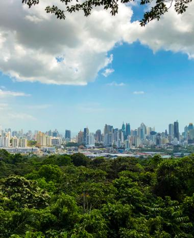
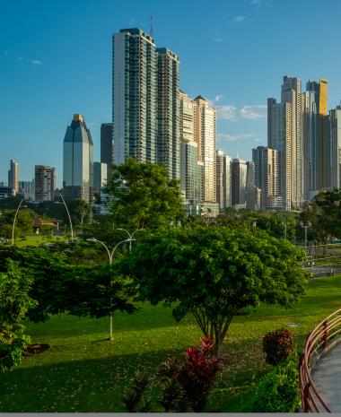
Panama City is a modern and ever-growing city, surrounded by a dense forest teeming with wildlife....